Kenmare ND - Features
Real People. Real Jobs. Real Adventures.

Thanks for reading some of the latest features about area people and events.
To view every page and read every word of The Kenmare News each week,
subscribe to our ONLINE EDITION!
Mouse River Park faces historically high flows and it's still raining in Canada
Tuesday morning, fire departments from Kenmare, Tolley, Mohall and Sherwood were mobilized by 10 am to assist with sandbagging and evacuation efforts at Mouse River Park.
6/22/11 (Wed)
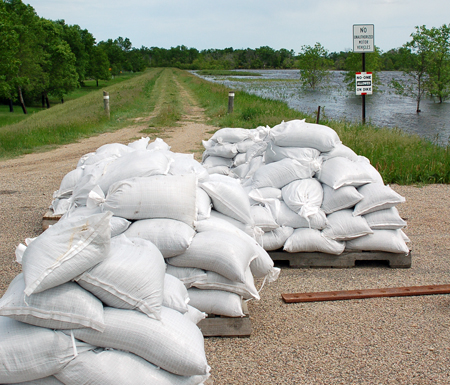
Building up . . . Sandbags will be used to increase the height of
the mile-long dike at Mouse River Park this week. The dike has been
saturated and pressured by high water for over two months, however,
and county officials had questions about the effectiveness of
sandbagging operations. Sunday's river level can be seen at right,
with the Park left of the dike.
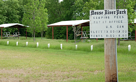
Ready, but closed . . . The campsites at Mouse River Park stand
vacated on a June weekend as record levels of water in the Mouse
River prevent seasonal residents and campers from enjoying the area.
Area firemen help with
evacuation and sandbagging
Tuesday morning, fire departments from Kenmare, Tolley, Mohall and Sherwood were mobilized by 10 am to assist with sandbagging and evacuation efforts at
According to Jim Burbidge, chairman of the Renville County Water Resource Board, their work may prove futile as the
“This morning, the projection at Sherwood was at 27,900 cfs (cubic feet per second),” Burbidge said Tuesday morning. “That’s higher than the 1904 flood and it’s still raining up [in
The latest blast from the Mouse comes after portions of the upper river basin in
Kristi Titus, Renville County Emergency Manager and members of the Renville County Water Resource Board, the Mouse River Park Board and the Renville County Sheriff’s Department called a meeting with Park property owners Sunday afternoon to discuss the situation at that point. The session ended with a mandatory and complete evacuation of the Park called for Thursday, June 23rd, at 5 pm.
Titus sent a request for the evacuation notice to Governor Dalrymple’s office. She also forwarded a question to the Army Corps of Engineers about how much weight the Park’s mile-long dike could hold from sandbags, and made a request for access to one of the sandbagging machines available in the state.
By Monday afternoon, those plans changed somewhat as Titus revised the mandatory evacuation to begin Tuesday, June 21st, at 5 pm. “We have the sandbag machine lined up,” she said Monday evening, “and right now, we’re waiting to hear back from the Corps to see what direction we should go and to find out how much is going over the dike if and when that happens.”
On Sunday, the river levels were projected to increase to 16,000 cfs at the Sherwood gauge. At the time, the combined releases from the Rafferty,
By Monday, Rafferty alone was releasing more than 17,000 cfs in an effort to protect the dam there, with high releases still coming from the other two reservoirs.
“Since Saturday, the Corps has raised over 14,000 cfs in what the projections have been,” Burbidge said Tuesday morning. He noted the previous high level reading for the river at the Park this spring was between 8,000 and 9,000 cfs.
Renville County Water Resource Board members estimated that raising the dike between 6 and 10 inches with sandbags would hold back the river running at 17,000 cfs. “A foot would be even better,” said board member Mark Cook.
Dike conditions
in question
However, the integrity of the dike was in question, given the fact that a system designed to handle two weeks of spring flooding when the ground was still partially frozen had now been pressured by high water for over two months. The narrow dike, wide enough for a single vehicle to drive along the top, has been saturated since April.
“All of us who have been walking the dike or driving the dike see its soft spots,” said Renville County Water Resource Board member Roger Sauer. “We can attest to it by all the seepage. How much more can it take?”
At this point, additional weight from clay or a plywood structure would weaken the dike further, according to assessments by the Water Board and the U.S. Army Corps of Engineers.
“The question is, will it withstand that much water even if it is that tall?” Sauer asked.
“It’s been there 25 years,” said Cook. “It’s settled and packed.”
He and Sauer agreed the dike would need repairs after the river levels dropped. “The dike still has to meet Corps standards after this is over,” said Sauer.
“They’re talking about three rows of sandbags needed to raise the dike approximately one foot high,” Burbidge said Tuesday morning, “but I don’t think that’s going to be enough. They’re talking about a reading of 26.5 feet at Sherwood, and the highest we’ve seen so far is 23.8 feet.”
As of Tuesday morning, the crest was projected at the Sherwood gauge by June 27th. “So we can assume the crest will be at the Park on the 28th or 29th,” Burbidge said, “but the water will be coming up before that, and I’m sure it’s going to be coming fast.”
At press time, a firm decision about the extent or duration of sandbagging operations had not been made by the Renville County Water Resource Board. “I don’t want anybody hurt,” said Burbidge. “It’s tough to give up the ship, but to quote Kenny Rogers, ‘You’ve got to know when to hold ‘em and know when to fold ‘em.’”
Check point
for sandbaggers
The Park will only be open to authorized personnel for the duration of the mandatory evacuation. Titus emphasized that emergency personnel will do everything they can to save the Park for as long as feasible, and that spectators would only hamper those efforts.
All sandbagging volunteers and emergency workers will enter the Park at the east entrance, where a check point will be staffed by law enforcement personnel. “We want people to check in when they come to the Park and to check out when they leave,” Titus said. “We need to know where everyone is, in case something does happen and we have to leave quickly.”
She noted the sandbagging machine could fill 1000 bags in an hour. “We need people to load and place those then,” she said, adding that a contact list of volunteers had been made.
Persons interested in volunteering to help with sandbagging efforts should contact Renae Johnson at the Renville County Sheriff’s Department at 701-263-7885.
Highest readings ever,
worst case scenario
Sunday was warm and sunny, the kind of June conditions that attract visitors to
An evacuation notice of one kind or another has been in effect since early April because of the high levels of the
The level of the river has remained steady inside the Park, but only because the top stoplog was put in place, for the first time ever, weeks ago in a flood control structure on the west side. Gates at the south flood control structure have been closed through the winter against water releases from the upper reservoirs, releases that have only increased through the spring runoff and frequent deluges of rain in May and June.
Property owners who met with Titus and other county officials in the Park’s gazebo Sunday afternoon had plenty of questions about how long the evacuation would last, what the expected river elevation would be, how much flooding could occur inside the Park, and how other Park residents from both sides of the border would be notified of the events.
Although some of those questions couldn’t be answered yet, Cook and Sauer explained the plans to protect the Park. “We’ve never been at these levels since the construction of this whole system,” Sauer said. “We’ve never had predictions this high. Right now, the river is seven feet higher outside the Park than inside.”
“And it’s probably going to go to nine feet,” Cook said.
They described conditions Park residents would notice on the river in the next few days. “You’re going to see water going down in the Park here, but that’s the calm before the storm,” Sauer said as he talked about how Lake Darling would be increasing releases to build storage space before the next crest arrived. “Unfortunately, the Park needs high outflow from
They also discussed a contingency plan to save the dike in the event of a breech or water levels that spilled over the dike’s top. “In the worst case scenario, beyond where we can hold it back anymore and the dike starts to fail,” Sauer said, “we plan to open the downstream gate and let water come in and back up to equalize the pressure.”
The plan has been discussed with and approved by Corps of Engineers staff. “We would leave that gate open then and when the river goes down, the water would drain out equally,” added Sauer. “If we can pump it at some point, then we’ll still pump. Understand, we’re not going to intentionally do this unless it’s already happening.”
Members of the audience joked with Cook and Sauer about building a diversion for the river from
“There’s some storage in the valley [after the water reaches Sherwood] to slow the water,” Cook said. “That’s going to help us a lot.”
Sauer shook his head. “We’re on uncharted territory here,” he said.
Editor's Note: By the time this story was published on June 22nd,
the inflows had increased again for Lake Darling. New release projections indicate the outflows will top 20,300 cfs from Lake Darling
by June 23rd or 24th. The city of Minot sounded its flood sirens for the nine evacuation zones and the inundation areas shortly before 1 pm
on June 22nd, five hours before the evacuation deadline of 6 pm that day. Readings at the Sherwood gauge, coming from Canada, indicated 30,000 or more cfs in inflows.