Kenmare ND - Features
Real People. Real Jobs. Real Adventures.

Thanks for reading some of the latest features about area people and events.
To view every page and read every word of The Kenmare News each week,
subscribe to our ONLINE EDITION!
Water on Des Lacs at historic levels
Water levels at the Des Lacs National Wildlife Refuge are high this spring, perhaps historically high, and it’s a situation Kenmare residents may have to deal with for a few weeks yet.
4/20/11 (Wed)
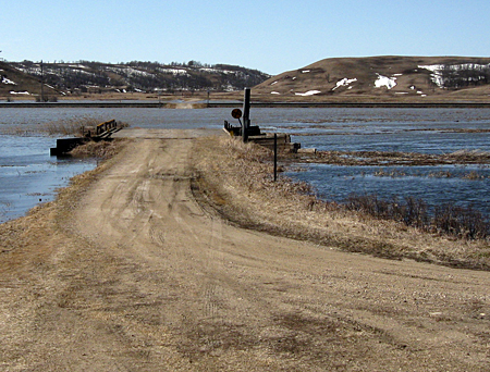
Bridge to nowhere . . . Access to the Brickyard Road is prevented
by high water levels on the Des Lacs lakes. Refuge personnel anticipate some damage to roads, bridges and water control structures, but
the water will have to recede before official assessments can be made.
Lake will remain high for weeks
By Caroline Downs
Water levels at the Des Lacs National Wildlife Refuge are high this spring, perhaps historically high, and it’s a situation Kenmare residents may have to deal with for a few weeks yet.
As of Monday afternoon, the elevation of the middle lake next to Kenmare was 1790.24 feet. “Our goal for operations is 1783.5 feet,” said Andy Jewett, biological technician. “Flood stage is 1788.5 feet, which is the spillway elevation.”
Water has been tumbling over the spillways since the first week of April, and local drivers have been slowing down to cross the low section of Ward County 1 west of town, where water started running across the roadway on April 8th.
At times, that pool has forced drivers to detour north through Niobe or south to Highway 50, and the water remained more than a foot deep on Monday.
With over 66 inches of snow recorded at the Des Lacs NWR from October 2010 through last weekend, equivalent to nearly 7 inches in moisture, spring runoff for the Des Lacs River was predicted to be high and messy. In fact, residents of Foxholm and Burlington struggled with river flows last week as water poured out of the coulees south of the Des Lacs NWR and gushed through their communities.
Refuge staff held back as much water as possible. “The Des Lacs refuge was not designed for flood mitigation,” said Kelly Hogan, project leader of the Souris River Basin National Wildlife Refuge Complex, “but it does store about 50,000 acre feet of water.”
In preparation for the anticipated runoff, refuge personnel prepared the water control structures to hold back as much water as possible. “Our intent is to let things settle down in the river,” Hogan said, referring to flows at Foxholm and Burlington, “before we start releasing. We’re going to have high levels on Des Lacs for a while.”
Jewett noted that water levels in the units south of the Middle Lake outside town have been dropping slightly in recent days, but inflows at Kenmare have continued. “Since Thursday, it’s come up a tenth of a foot,” he said.
Several local residents noted changes in the east channel next to town, where water flowed north for several days. Jewett explained the channel allows refuge staff to divert water to the upper lake, which is the main water storage unit for the refuge. “At times early last week, the upper lake was coming up almost a foot a day,” he said, “although it leveled out by mid-week.”
With river levels down by several feet at Foxholm now, Jewett is starting to release more water, with maximum flows at about 500 cubic feet per second. “This is going to take a while, though,” he said, “and then we’ll see how much damage was done and how much repair work needs to be done.”
Access to the refuge is limited because of water levels and potential damage. The Boat Dock Road is closed north of Kenmare because of water covering portions of the road, as well as snowdrifts.
The Scenic Lake Road south of town is open to the city lagoons. “Then it’s closed for several miles because portions are either washed out or water has backed up onto the road,” said Jennifer Jewett, education and outreach coordinator at the refuge.
Tasker’s Coulee is not accessible because snowdrifts still block the road, and the Brickyard Road is under water.
Hogan didn’t expect to find any washed-out dikes on the refuge. “There will be some erosion and some riprap displacement,” he said, “but we haven’t sustained massive damage.”
Whooping cranes spotted
Despite the high water, refuge activities continue. Ducks and geese have returned to nest for the season, although some of their preferred sites may be under water at this time.
Three whooping cranes were sighted Monday west of Kenaston, with refuge personnel monitoring their presence. Individuals are asked to report any and all whooping crane sightings to the refuge at 701-385-4046 ext. 221.
New refuge manager
The staff is also preparing for the arrival of new manager Chad Zorn. Zorn previously worked at the Des Lacs and Lostwood NWRs before serving with the U.S. Fish & Wildlife Service at Valley City. Zorn, his wife Jennifer and their twin sons will move to Kenmare in late May, and Zorn will begin his appointment during the first week of June.
In the meantime, Kenmare residents should expect to see lake levels slowly decline near town. “If I can get the water level below the road in the next week,” said Andy Jewett, “I’ll be happy.”
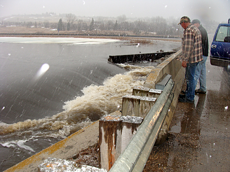
Water in the Middle Des Lacs Lake at Kenmare rose to the highest level
seen in years during the first week in April and started rushing over the spillway at the bridge immediately west of town on Ward County 1.
A few hundred yards farther west, water continues to pool across
the road at a depth of nearly one foot.