Kenmare ND - Features
Real People. Real Jobs. Real Adventures.

Thanks for reading some of the latest features about area people and events.
To view every page and read every word of The Kenmare News each week,
subscribe to our ONLINE EDITION!
Runoff quickly turns from a trickle to a gush
Kenmare residents experienced their own flood event Saturday as water at the Des Lacs National Wildlife Refuge immediately west of town trickled, then gushed, then closed Ward County roads 1 and 2.
5/01/13 (Wed)
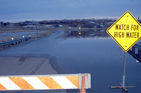
High water looking west . . . Water spreads across Ward County Road 1
immediately west of Kenmare early Saturday night after daytime
temperatures climbed past 70 degrees and thawed the late season
snowdrifts covering the landscape north and west of town. By Sunday
morning, the water had receded and the road was dry.
By Caroline Downs
Kenmare residents experienced their own flood event Saturday as water at the Des Lacs National Wildlife Refuge immediately west of town trickled, then gushed, then closed Ward County roads 1 and 2.
“Everything ramped up pretty good Friday night,” said refuge manager Chad Zorn. “I was getting text messages about the water by Saturday morning.”
The high water resulted from the sudden rise in temperatures to the 60s and 70s on Friday and Saturday that thawed a deep snow cover locked in place since early March.
“This was the product of a fast melt after a cold spring,” Zorn said. “Some areas ran as hard as I’ve ever seen them.”
He explained that Unit 3, the pool on the north side of Ward County 1, filled from runoff flowing out of Rodin’s Coulee to the northwest. That coulee actually drains a large area, including the flat fields around Niobe and the eastern side of the hilly coteau region in Burke County.
Unit 3 also receives the runoff from a smaller coulee on the east side of the county road.
“We had an impressive amount of water in there,” said Zorn. “We only have a maximum of 107 acre feet of storage in Unit 3, so it is going to fill quickly and it is going to run over.”
The low section of Ward County 1 functions as a spillway for that water unit, reinforced by concrete on both sides of the road according to Zorn. “It worked like it was supposed to,” he said. “The spillway does not allow Mother Nature to find a weak link in a dam or a road. By design, Unit 3 dumps its water into Unit 4, the lake outside of town, and works its way through the system.”
Water now
leaving the refuge
Although no water was flowing out through the Des Lacs River out of the south end of the refuge last week at this time, that changed Saturday. Zorn noted the refuge also receives the runoff from Tasker’s Coulee and Feldman’s Coulee downstream, and all three drainages channeled rushing water into the river system.
“Over the weekend, the water from Unit 3 and everything downstream ultimately worked its way through the refuge,” said Zorn. “We’re running full pools right now, and water is going over all the spillways.”
He and assistant refuge manager Jason Melin monitored the situation through the weekend. Boards were set in place on all the refuge’s water structures downstream of Kenmare to hold as much water as possible.
Ironically, as of Monday night, the Middle Des Lacs Lake still sported a layer of rotting ice. “You would get the impression we’re frozen all the way down,” Zorn said, “but the south end of the refuge is totally open and flowing freely.”
The lake level at Kenmare has come up three to four feet during the past week, with water pushing against the ice layer from the bottom. Water will continue to flow from the Middle Des Lacs Lake into other units on the refuge. “We can’t stop any more of the water until it quits going over our spillways,” explained Zorn, “but it appears we’ve seen the high crest.”
To alleviate pressure on Unit 3, which Zorn described as a bottleneck for water coming from the two coulees, personnel removed boards from a dike on the refuge directly below the Kenmare Country Club. Levels of the Upper Des Lacs Lake north of Kenmare have not shown an increase, so water from Unit 3 is diverted there.
“It’s pooling back around under the bridge, which pushes the water north,” Zorn said. “The lake up there has 17,000 to 18,000 acre feet of storage.”
Minimal damage
from high water
Saturday night’s road closure decisions were made by Ward County personnel, but those roads were dry again by Sunday morning. “Water levels there have come down another six inches since this morning,” Zorn said Monday.
He emphasized that despite the water roaring over the spillway on Ward County 1, no damage occurred.
However, he discovered minor damage to the dike and the maintenance trail at Tasker’s Coulee on Monday. “From the way the vegetation looks there, the whole mouth of that coulee must have been under water on Saturday,” he said. “It’s still running the culvert full, but it’s a fraction of the amount it was.”
He added that in discussions with engineers about a road project there scheduled for this summer, a section of the road will be rebuilt as a spillway.
The Scenic Lake Road south of Kenmare was not damaged by rising waters.
The Boat Dock Road north of town remains closed, but last week Zorn directed staff members to clear a trail through the drift filling the road at the far north end. “That should help speed up the melting process,” he said. “I’m glad people are being patient with me on that road opening.”
Lake Darling releases
to follow Des Lacs
River water
Zorn will continue to coordinate flows from the Des Lacs River with personnel at the Upper Souris NWR. “Communication is the critical factor right now,” said Tom Pabian, manager of the Upper Souris NWR.
As of Monday, no water was being released from the Lake Darling Dam at the refuge. “The Army Corps of Engineers’ plan is to leave the gates closed until at least Tuesday,” Pabian said. “They will re-evaluate the situation Tuesday and start releasing water Tuesday or Wednesday.”
He continued, “We’ll try to follow the recession of the Des Lacs River water. It has to recede a bit more.”
Pabian explained that inflows to Lake Darling on Monday were coming from the Boundary Reservoir and local runoff in Saskatchewan. No water was being released from the Rafferty and Alameda reservoirs. “Once they hit their target levels, they’ll start releasing,” he said.
Lake Darling was drawn down to a low level at 1591’, but Pabian said refuge personnel were confident the lake could return to its summer supply level of 1597’ by June 1st. “We want to make sure we release enough water to follow this [Des Lacs River] event, but not so much water that we cause another flood event,” he said.
Pabian noted his biggest concern about water over the weekend was the impact of the sudden rise of the Des Lacs River.
“A few folks saw some water this weekend,” he said, “but now it’s starting to recede.”
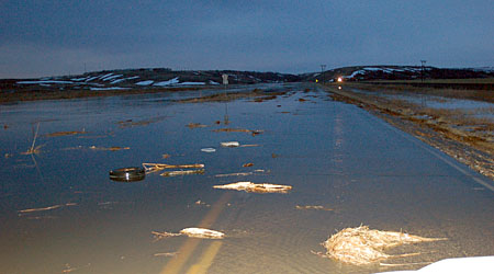
Flood stage to the north . . . Ward County Raod 2, heading northwest
from Kenmare, is flooded the night of April 27th as runoff from Rodin's
Coulee fills the Unit 3 pool on the Des Lacs National Wildlife Refuge
west of the city. The onslaught of rushing water pushed dried
cattails, trash and even an abandoned tire across the roadway,
but water levels dropped by the next morning.